

Coffee & Tornadoes
Coffee & Tornadoes

If I’m not writing in here after observing historically significant tornadoes, then what are we really doing here?
I’m in Gainesville, Florida this week with the family. Former Central Illinoisans, my in-laws migrated to Florida in the early 2010s when my father-in-law took a job as a professor at the University of Florida. The trip spoils us every time. His home is tucked away in the woods, still somehow centrally located in Gainesville, while the city itself is surrounded by plenty of swampy natural beauty. This is my favorite time of the year to visit. Beside the fact that I’m a cranky guy in hot & muggy summertime weather, Florida in March is full of spring vibes. Plants are bursting with color, the weather is perfect, and the air smells like flowers. It feels like a little spring preview. Enjoy a week of spring bursting down here, return to the Midwest and let spring burst at home!
We were treated to a wonderfully stormy night last night, but that’s not what motivated me to circle back here and write, so let’s talk about what happened on Monday, February 27th, 2023.
The evening before I was decidedly not in storm chase mode, though there was a pretty good signal for morning storms and even a non-ignorable reason to believe there could not only be a couple strong storms, but maybe even rotating storms.
A compact, but potent upper-level wave would sweep through the Southern Plains on Sunday night initiating supercell thunderstorms that eventually grew upscale into a linear system that produced several embedded tornadoes, one of which struck Norman, Oklahoma.
I tossed a couple of posts into the social media feeds about potential morning storms in central Illinois and then went off to bed.

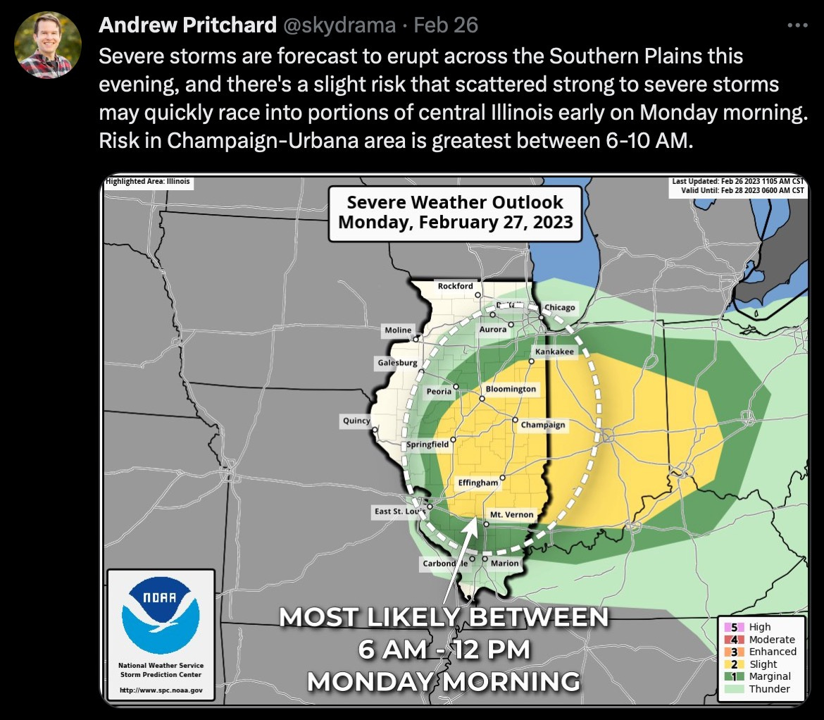
I got up around 4:30 AM on Monday, a little earlier than my usual 5 AM alarm wanting some extra time to calibrate if there were indeed storms in the area when I woke. Overnight severe storms from Oklahoma had waned as they moved into Illinois during the pre-dawn hours. We enjoyed some light to moderate thunderless rain in Champaign-Urbana while I got into my morning work.
Keeping an eye on radar, an interesting evolution was occurring. Morning rain continued to lift out of the area, with a dry slot allowing clearing skies and the morning sun to spread across central Illinois. Between 7 AM and 8 AM, isolated thunderstorms began to erupt just ahead of the surface low within a small corridor of instability beneath the cold upper-level low overhead.
Even before producing any lightning, you could see some broad, weak rotation in the little spuds as they went up on radar to our west and south. I wasn’t necessarily ready to jump in the car and go chasing updrafts all over central Illinois, but I knew that this warranted a watchful eye. With robust 0-3 km CAPE and a vorticity rich environment ahead of the surface low - it may have been 7 AM on February 27th, but the environment was otherwise primed for mini-supercells.
Around 8 AM a rather intense storm near Cerro Gordo, or about 45 miles southwest of Champaign-Urbana began to get my attention. Look, I sit here and preach “Mother Nature doesn’t own a calendar or a clock, if the ingredients are there it doesn’t matter what time or day it is” but I still could not get myself into tornado-chase mode. I was just kind of thinking hey, it’s the last week in February, it might be fun to go drive into that little storm and film some hail. I assumed there’d at least be an opportunity to get into a downpour of pea-sized hail or something, anything to kick start the looming spring storm season.
I poured a fresh cup of coffee in a to-go mug, grabbed my video camera and gopro (see, still not even in chase mode enough to grab my entire bin of chase gear) and hopped in the car. My plan was rather simple - drive around to the southwest side of Champaign-Urbana and take a look at the storm. Maybe follow it for a few minutes, and then head back home for my busy work day.
Coming around the west side of town I noted increasing rotation on radar - still, I wasn’t convinced. Probably a fluke, I figured, or a little circulation that’ll otherwise do nothing because it is 8 in the morning on a Monday in February. Still, I finally switched into a more formal chase mode at this point, plotting a landing position just ahead of the intensifying storm along Staley Road on the west side of Champaign.
It wasn’t more than 30 seconds after I pulled to the side of the road that I noted an obvious funnel cloud developing on the southern side of the updraft base. This was clearly no benign funnel cloud and showed every intention of touching down. In a way, this is that ‘worst-case-scenario’ where I’m suddenly watching a tornado touch down on the west side of my hometown, moving toward it. I immediately got on the phone with our local EMS as the tornado touched down, a ghostly gray elephant trunk tornado that fully condensed to the ground.
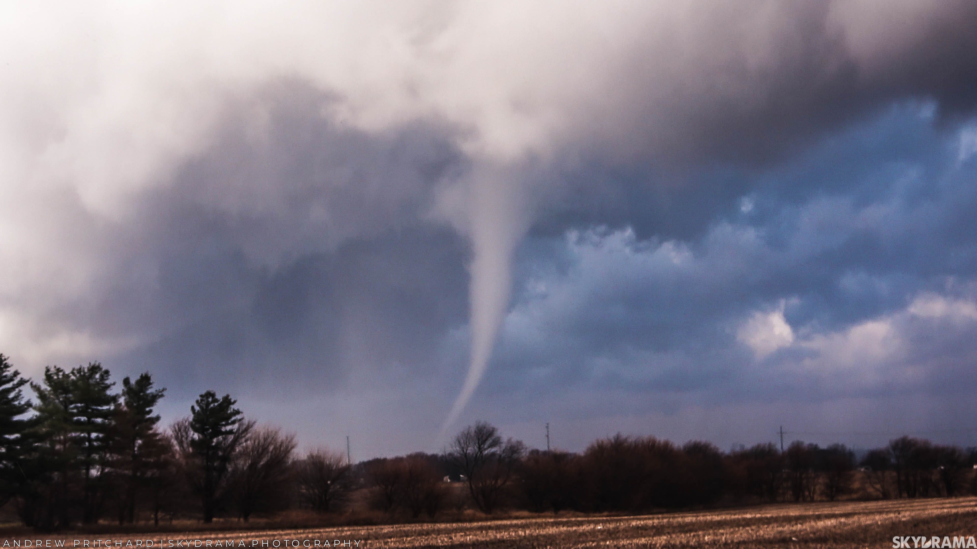
After reporting the tornado, my next phone call was back home to my wife Sophie. I’d just said goodbye to her 20 minutes earlier, saying I was headed off to keep a rotating rain shower honest and felt compelled to let her know that I was indeed watching a tornado on the west side of town. The tornado would miss our house so I wasn’t worried, but knew the imment tornado siren blast would get her calling me anyway.
The tornado lasted a couple of minutes before roping out in dramatic fashion in front of a broken blue sky and cumulous backdrop.
Following the storm around to the north side of town at 8:55 AM I noted a new funnel cloud developing, which soon touched down near Interstate 57. Two tornadoes now before 9 AM. Incredible.

After filming the second tornado from the industrial park on the northwest side of Champaign I let this first storm go, noting a line of new cells popping up to my south, retracing the same path as the first storm. All of these little cells had some weak rotation, so I figured since I was out I might as well stay out.
Another tornado warning was issued for the Champaign-Urbana area around 9:45 AM, prompting another sounding of the outdoor warning sirens but this storm never exhibited much in the way of cloud base rotation. I did a couple live over-the-air updates on AM 580 before returning home, pulling into the driveway in a shower of pea-sized hail.
The two tornadoes west and north of Champaign on February 27th, 2023 were the first tornadoes ever to be recorded in Champaign County in the month of February. They’re also the earlier tornadoes I’ve ever observed on the calendar or the clock - first February tornadoes, first morning tornadoes.
Anecdotally, Monday’s are typically my busiest work day of the week. I was fully not prepared to get home from observing a pair of photogenic tornadoes just outside my hometown and then have to pivot into sitting down at my desk and begin a long work day. I will say, it’s days like this that I’m incredibly grateful that I get to live my dream of working in the weather world. At least when I’m feeling distracted or unmovitated, my work is still my love.
As I noted above, these spring break trips to Florida always feel like a little spring preview. That first taste of warm & humid air, the smell of spring always gives me life and a shot of adrenaline for Midwestern spring. But here we are in 2023, and the spring adrenaline is already flowing. I was chasing a tornado warned, previously tornadic supercell in January, and in February I’m on the board with two tornadoes.
What will March-April-May deliver?
Here’s my full VLOG (17 min runtime) from the February 27th, 2023 Champaign, Illinois tornadoes: